OFFICIAL
DESCRIPTION CHANGE
OFFICE:
Transportation Data
EFFECTIVE DATE: 12-2006
ENTERED
BY: Darlene Bovee
ENTERED
DATE: 02-26-2007
New
description ‑
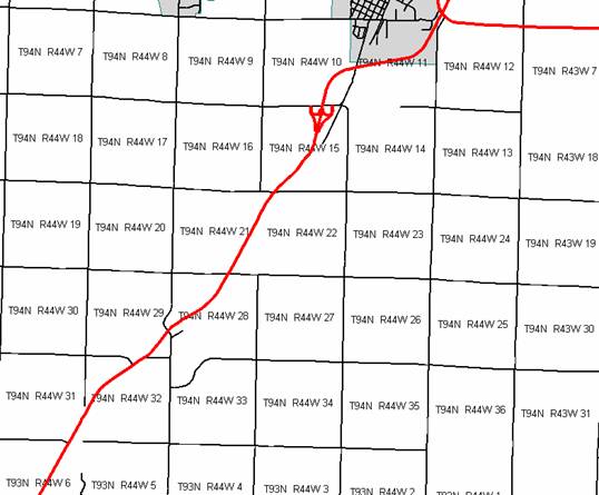
Beginning
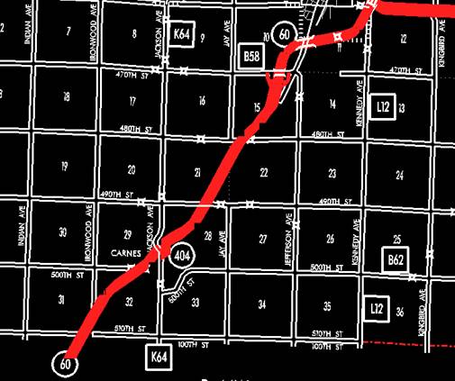
on the Sioux‑Plymouth County line at a point approximately 770 feet west
of the SE Corner Section 31‑T94N‑R44W, Sioux County (NE Corner
Section 6‑T93N‑R44W, Plymouth County); thence in a northeasterly
direction through Sections 31, 32, 29, 28, 21, 22, and 15‑T94N‑R44W
to approximately 460 feet east of the Center of said Section 15; thence
northerly and northeasterly through Sections 15, 10, and 11‑T94N‑R44W
to the south corporation line of Alton (approximately 2650 feet north and 1990
feet east of the SW Corner of said Section 11) connecting with an unnamed
street.
Beginning at the south corporation
line connecting with an unnamed street; thence northeasterly to the east
corporation line (NW Corner Section 12-T94N-R44W).
Beginning
again on the east corporation line of Alton connecting with an unnamed street;
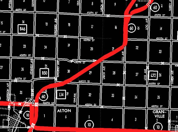
thence northeasterly, northerly, and northeasterly through Section
1-T94N-R44W, Section 36‑T95N‑R44W,
and Sections 31, 30, 29, 20 and 21 to a point approximately to a point
approximately 550 feet south of the NE Corner Section 21‑T95N‑R43W;
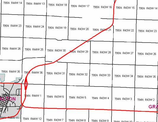
thence northerly following substantially the section line of Sections 22 and 15‑T95N‑R43W
to approximately 1780 feet south of the NW Corner of said Section 15; thence
northeasterly and northerly through Sections 15, 10, 11, and 2-T95N-R43W to the
east corporation line of Hospers connecting with an unnamed street
(approximately 1557 feet north and 628 feet east of the SW Corner of said
Section 2).
Hospers:
Beginning at the east corporation
line connecting with an unnamed street; thence northwesterly to the north
corporation line (approximately 2637 feet north and 311 feet east of the SW
Corner of Section 2-T95N-R43W).
Beginning again on the north
corporation line of Hospers connecting with an unnamed street; thence in a northwesterly
direction to the east corporation line of Hospers connecting with an unnamed
street (approximately 3695 feet north of the SW Corner of Section 2-T95N-R43W).
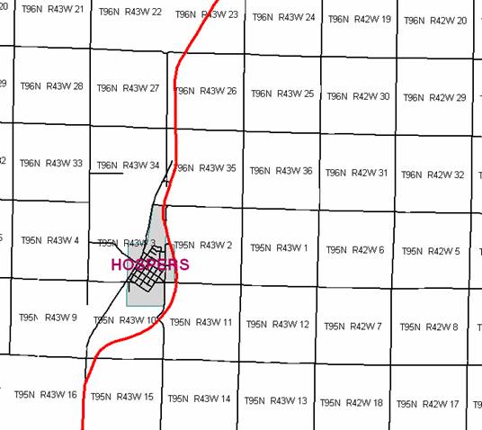
Hospers:
Beginning at the east corporation
line connecting with an unnamed street; thence northwesterly and northerly to
the north corporation line (approximately 166 feet west of the NW Corner of
Section 2-T95N-R43W).
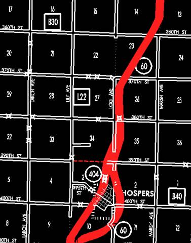
Beginning
again on the north corporation line of Hospers connecting with an unnamed
street; thence northeasterly, northerly, and northeasterly through Sections 34,
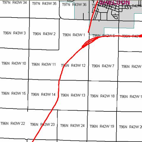
35, 26, 23, 14, 13, 12, and 1‑T96N‑R43W to the Sioux‑O'Brien
County line (approximately 1592 feet north of the SE Corner of said Section 1)
(SW Corner Section 6-T96N-R42W, O’Brien County).
OFFICIAL
DESCRIPTION CHANGE
OFFICE:
Transportation Data
EFFECTIVE DATE: 12-2005
ENTERED
BY: Stefani Wonders
ENTERED
DATE: 08-30-2006
New
description ‑
Beginning
on the Sioux‑Plymouth County line at a point approximately 700 feet west
of the SE Corner Section 31‑T94N‑R44W, Sioux County (NE Corner
Section 6‑T93N‑R44W, Plymouth County); thence in a northeasterly
direction along the west side of the Chicago and Northwestern Railway and
substantially parallel thereto through Sections 31, 32, 29, 28, 21, 22, and 15‑T94N‑R44W
to approximately 695 feet east of the Center of said Section 15; thence
northerly and northeasterly through Sections 15, 10, and 11‑T94N‑R44W
to the south corporation line of Alton (approximately 2710 feet north and 2780
feet east of the SW Corner of said Section 11) connecting with an unnamed
street.
Beginning at the south corporation
line connecting with an unnamed street; thence northeasterly to the east
corporation line (NW Corner Section 12-T94N-R44W).
Beginning
again on the east corporation line of Alton connecting with an unnamed street;
thence northeasterly, northerly, and northeasterly through Sections 1-T94N-R44W
and 36‑T95N‑R44W to a point on the east side of the Chicago and
Northwestern Railway approximately 2671 feet east of the W ¼ Corner of said
Section 36; thence in a northeasterly direction along the east side of said
railway and substantially parallel thereto through Section 36‑T95N‑R44W
and Sections 31, 30, 29 and 20‑T95N‑R43W to a point approximately
514 feet north of the SE Corner Section 20‑T95N‑R43W; thence in a
northeasterly direction through Section 21‑T95N‑R43W to a point
approximately 900 feet south of the NE Corner Section 21‑T95N‑R43W;
thence northerly following substantially the section line of Sections 22 and 15‑T95N‑R43W
to approximately 1753 feet south of the NW Corner of said Section 15; thence
northeasterly and northerly through Sections 15, 10, 11, and 2-T95N-R43W to the
east corporation line of Hospers connecting with an unnamed street
(approximately 1672 feet north and 853 feet east of the SW Corner of said
Section 2).
Hospers:
Beginning at the east corporation
line connecting with an unnamed street; thence northwesterly to the north
corporation line (approximately 2637 feet north and 482 feet east of the SW
Corner of Section 2-T95N-R43W).
Beginning
again on the north corporation line of Hospers connecting with an unnamed
street; thence in a northwesterly direction to the east corporation line of
Hospers connecting with an unnamed street (approximately 3865 feet north and 56
feet west of the SW Corner of Section 2-T95N-R43W).
Hospers:
Beginning at the east corporation line
connecting with an unnamed street; thence northwesterly and northerly to the
north corporation line (approximately 225 feet west and 29 feet south of the NW
Corner of Section 2-T95N-R43W).
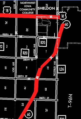
Beginning
again on the north corporation line of Hospers connecting with an unnamed
street; thence northeasterly, northerly, and northeasterly through Sections 34,
35, 26, 23 and 14‑T96N‑R43W to a point approximately 1320 feet
north and 1320 feet west of the SE Corner Section 14‑T96N‑R43W;
thence in a northeasterly direction through said Section 14 to a point near the
E ¼ Corner Section 14‑T96N‑R43W; thence northerly following
substantially the section line of Section 13‑T96N‑R43W to a point
on the east side of the Chicago and Northwestern Railway near the NE Corner Section
14‑T96N‑R43W; thence in a northeasterly direction along the east
side of said railway and substantially parallel thereto through Sections 12 and
1‑T96N‑R43W to the Sioux‑O'Brien County line (approximately
3753 feet north of the SE Corner of said Section 1) (west corporation line of
Sheldon connecting with Woodcock Avenue).
OFFICIAL
DESCRIPTION CHANGE
OFFICE:
Transportation Data
EFFECTIVE DATE: 9-16-2004
ENTERED
BY: Stefani Wonders
ENTERED
DATE: 08-30-2006
New
description ‑
Beginning
on the Sioux‑Plymouth County line at a point approximately 700 feet west
of the SE Corner Section 31‑T94N‑R44W, Sioux County (NE Corner
Section 6‑T93N‑R44W, Plymouth County); thence in a northeasterly
direction along the west side of the Chicago and Northwestern Railway and
substantially parallel thereto through Sections 31, 32, 29, 28, 21, 22, and 15‑T94N‑R44W
to approximately 695 feet east of the Center of said Section 15; thence northerly
and northeasterly through Sections 15, 10, and 11‑T94N‑R44W to the
south corporation line of Alton (approximately 2710 feet north and 2780 feet
east of the SW Corner of said Section 11) connecting with an unnamed street.
Beginning at the south corporation
line connecting with an unnamed street; thence northeasterly to the east
corporation line (NW Corner Section 12-T94N-R44W).
Beginning
again on the east corporation line of Alton connecting with an unnamed street;
thence northeasterly, northerly, and northeasterly through Sections 1-T94N-R44W
and 36‑T95N‑R44W to a point on the east side of the Chicago and
Northwestern Railway approximately 2671 feet east of the W ¼ Corner of said
Section 36; thence in a northeasterly direction along the east side of said
railway and substantially parallel thereto through Section 36‑T95N‑R44W
and Sections 31, 30, 29 and 20‑T95N‑R43W to a point approximately
514 feet north of the SE Corner Section 20‑T95N‑R43W; thence in a
northeasterly direction through Section 21‑T95N‑R43W to a point
approximately 900 feet south of the NE Corner Section 21‑T95N‑R43W;
thence northerly following substantially the section line of Sections 22, 15
and 10‑T95N‑R43W to a point approximately 400 feet north of the SW
Corner Section 10‑T95N‑R43W; thence in a northeasterly direction
through Sections 10 and 3‑T95N‑R43W to the west corporation line of
Hospers, connecting with an unnamed street (approximately S ¼ Corner of said
Section3).
Hospers:
Beginning at the west corporation
line connecting with an unnamed street; thence northeasterly to the north
corporation line (approximately 1716 feet west and 2822 feet south of the SE
Corner of Section 3-T95N-R43W).
Beginning
again on the north corporation line of Hospers connecting with an unnamed
street on the east side of the Chicago and Northwestern Railway; thence in a
northeasterly, northerly, and northeasterly direction along the east side of
said railway and substantially parallel thereto through Section 3‑T95N‑R43W
and Sections 34, 35, 26, 23 and 14‑T96N‑R43W to a point
approximately 1320 feet north and 1320 feet west of the SE Corner Section 14‑T96N‑R43W;
thence in a northeasterly direction through said Section 14 to a point near the
E ¼ Corner Section 14‑T96N‑R43W; thence northerly following
substantially the section line of Section 13‑T96N‑R43W to a point
on the east side of the Chicago and Northwestern Railway near the NE Corner
Section 14‑T96N‑R43W; thence in a northeasterly direction along the
east side of said railway and substantially parallel thereto through Sections
12 and 1‑T96N‑R43W to the Sioux‑O'Brien County line (west
corporation line of Sheldon) connecting with Woodcock Avenue.
OFFICIAL DESCRIPTION CHANGE
COUNTY:
Sioux
ROUTE:
STAFF
ACTION NUMBER:
S-87-1511
APPROVAL
DATE: 5-13-87
New Description
‑
Beginning
on the Sioux‑Plymouth County line at a point approximately 700 feet west
of the SE Corner Section 31‑T94N‑R44W, Sioux County (NE Corner
Section 6‑T93N‑R44W, Plymouth County); thence in a northeasterly
direction along the west side of the Chicago and Northwestern Railway and
substantially parallel thereto through Sections 31, 32, 29, 28, 21, 22, 15, 10
and 11‑T94N‑R44W to the south corporation line of
Beginning
on
Beginning
again on the north corporation line of Alton connecting with 3rd Avenue (W.
junction Iowa 10); thence easterly following substantially the section line of
Section 2‑T94N‑R44W to a point near the NE Corner said Section 2
(E. junction Iowa 10); thence in a northeasterly direction through Sections 35
and 36‑T95N‑R44W to a point on the east side of the Chicago and
Northwestern Railway approximately ¼ mile east of the W ¼ Corner Section 36‑T95N‑R44W;
thence in a northeasterly direction along the east side of said railway and
substantially parallel thereto through Section 36‑T95N‑R44W and
Sections 31, 30, 29 and 20‑T95N‑R43W to a point approximately ¼
mile north of the SE Corner Section 20‑T95N‑R43W; thence in a
northeasterly direction through Section 21‑T95N‑R43W to a point
approximately 900 feet south of the NE Corner Section 21‑T95N‑R43W;
thence northerly following substantially the section line of Sections 22, 15
and 10‑T95N‑R43W to a point approximately 400 feet north of the SW
Corner Section 10‑T95N‑R43W; thence in a northeasterly direction
through Sections 10 and 3‑T95N‑R43W to the west corporation line of
Hospers, connecting with 1st Avenue.
Hospers:
Beginning
on
Beginning
again on the north corporation line of Hospers connecting with 1st Avenue on
the east side of the Chicago and Northwestern Railway; thence in a
northeasterly, northerly, and northeasterly direction along the east side of
said railway and substantially parallel thereto through Section 3‑T95N‑R43W
and Sections 34, 35, 26, 23 and 14‑T96N‑R43W to a point
approximately ¼ mile north and ¼ mile west of the SE Corner Section 14‑T96N‑R43W;
thence in a northeasterly direction through said Section 14 to a point near the
E ¼ Corner Section 14‑T96N‑R43W; thence northerly following
substantially the section line of Section 13‑T96N‑R43W to a point
on the east side of the Chicago and Northwestern Railway near the NE Corner
Section 14‑T96N‑R43W; thence in a northeasterly direction along the
east side of said railway and substantially parallel thereto through Sections
12 and 1‑T96N‑R43W to the Sioux‑O'Brien County line (W.
corporation line of Sheldon) connecting with
COMMISSION
ORDER
DIVISION:
Planning & Research
COMMISSION
ORDER NUMBER:
PR-79-272
SUBMITTED
BY: C.I. MacGillivray
MEETING
DATE: 11-2-78
DISCUSSION/BACKGROUND:
Iowa
60 begins on the Sioux‑Plymouth County line approximately 6 miles south
and one mile west of Orange City, and travels generally northeasterly via Alton
and Hospers to the Sioux‑O'Brien County line near the southwest corner of
Sheldon, Iowa.
Due
to a review of our Primary Road System Records Iowa 60 in
PROPOSAL/ACTION
RECOMMENDATION:
It
is recommended that the old description of
Locate
Beginning
on the Sioux‑Plymouth County line at a point approximately 700 feet west
of the SE Corner Section 31‑T94N‑R44W, Sioux County (NE Corner
Section 6‑T93N‑R44W, Plymouth County); thence in a northeasterly
direction along the west side of the Chicago and Northwestern Railway and
substantially parallel thereto through Sections 31, 32, 29, 28, 21, 22, 15, 10,
and 11‑T94N‑R44W to the south corporation line of the City of
Beginning on the south corporation
line connecting with an unnamed street; thence northeasterly to the north
corporation line connecting with an unnamed street.
Beginning
again on the north corporation line of the City of Alton connecting with an
unnamed street (west junction Iowa 10); thence easterly following substantially
the section line of Section 2‑T94N‑R44W to a point near the NE
Corner said Section 2 (east junction Iowa 10); thence in a northeasterly
direction through Sections 35 and 36‑T95N‑R44W to a point on the
east side of the Chicago and Northwestern Railway approximately ¼ mile east of
the W ¼ Corner Section 36‑T95N‑R44W; thence in a northeasterly
direction along the east side of said railway and substantially parallel
thereto through Section 36‑T95N‑R44W and Sections 31, 30, 29, and
20-T95N‑R43W to a point approximately ¼ mile north of the SE Corner
Section 20‑T95N‑R43W; thence in a northeasterly direction through
Section 21‑T95N‑R43W to a point approximately 900 feet south of the
NE Corner Section 21‑T95N‑R43W; thence northerly following
substantially the section line of Sections 22, 15, and 10‑T95N‑R43W
to a point approximately 400 feet north of the SW Corner Section 10‑T95N‑R43W;
thence in a northeasterly direction through Sections 10 and 3‑T95N‑R43W
to the west corporation line of the City of
Hospers:
Beginning on the west corporation
line connecting with an unnamed street; thence in a northeasterly direction to
the north corporation line connecting with an unnamed street.
Beginning
again on the north corporation line of the City of Hospers connecting with an
unnamed street on the east side of the Chicago and Northwestern Railway; thence
in a northeasterly, northerly, and northeasterly direction along the east side
of said railway and substantially parallel thereto through Section 3‑T95N‑R43W
and Sections 34, 35, 26, 23, and 14‑T96N‑R43W to a point
approximately ¼ mile north and ¼ mile west of the SE Corner Section 14‑T96N‑R43W;
thence in a northeasterly direction through said Section 14 to a point near the
E ¼ Corner Section 14‑T96N‑R43W; thence northerly following
substantially the section line of Section 13‑T96N‑R43W to a point
on the east side of the Chicago and Northwestern Railway near the NE Corner
Section 14‑T96N‑R43W; thence in a northeasterly direction along the
east side of said railway and substantially parallel thereto through Sections
12 and 1‑T96N‑R43W to the Sioux‑O'Brien County line (west
corporation line of the City of Sheldon) connecting with an unnamed street.
REVISED:
5-13-87